By Sahar Chmais
A large stretch of parkland is to be preserved from Austin to San Antonio, with Hays County sandwiched in between, connecting the metropolitan areas.
By the Texas Bicentennial in 2036, the Great Spring Project (GSP) connecting the state Capitol to the Alamo will be complete.
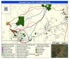
The GSP will acquire 18 miles of land between San Marcos, Kyle and Buda through the San Marcos Loop & Check Trail and the Emerald Crown Trail. This will connect to the Violet Crown Trail and eventually to Barton Springs in Austin. According to the GSP, there are some active stakeholder groups in San Antonio and New Braunfels it is working with to develop a network of trails to connect those cities and then connect San Marcos to New Braunfels.
The biggest collaborators in Hays County, besides the cities, include the San Marcos Greenbelt Alliance, Meadows Center for the Environment, San Marcos River Foundation, along with other local organizations and agencies.
Besides creating a connector between Austin and San Antonio, the project carries some environmental impacts. This project will protect the Edwards Aquifer and four great springs between San Antonio and Austin: Barton, San Marcos, Comal and San Antonio springs. It will do so through land conservation, which in turn protects native species and their habitats.
There is an added social impact as well. According to the GSP, it will improve the quality of life by expanding public access to nature. In the short term and long term, there will also be an economic benefit. The trail system is expected to increase tourism, and the exposure to nature will encourage more people to live and work in Central Texas.
This project was part of Hays County Proposition B which was on the ballot in November 2020. Prop B included a variety of projects for trail improvement, connectivity and land conservation, recommended by the Parks and Open Space Advisory Committee. Other projects in the proposition include Emerald Crown Trail, Violet Crown Trail, Old Fitzhugh Road Trail, the Kyle Fajita Fields project, the Capes Fishing Pond project and the protection of an 844-acre tract above the recharge zone of the Edwards Aquifer that feeds San Marcos Springs.
The network of trails will be on public and private land. It will also include land held by other nonprofits, government agencies and neighborhood associations. The GSP said it is working with willing landowners for the portions of the trails on private properties.
Funding for the project will come from a combination of public funding and private philanthropy, according to the GSP.
Details on trail routes are being discussed with the stakeholders, community leaders and local volunteer groups.